
Myanmar, which has a very long coastal line at 2,228 kilometers, is mainly exposed to water-related disasters. The decade before Cyclone Nargis struck Myanmar in 2008, large-scale disasters had been occurring in three- to five- year intervals.
Since the cyclone, there has been a major disaster almost every year on average over the past 10 years. And since 2018, about two major disasters have struck yearly. This clearly demonstrates that the disaster risks are growing and getting more complex these days. Out of those significant disasters in the last two decades, 80 per cent are caused by water related hazards.
In the wake of the catastrophic Cyclone Nargis, the Myanmar government has taken various measures towards disaster risk reduction and management. Aiming to make long-term investments in disaster risk governance, the government drafted the Myanmar Action Plan on Disaster Risk Reduction (MAPDRR) in 2010. By implementing the very first MAPDRR, partnership and coordination amongst the local, national and international stakeholders had been remarkably strengthened. In 2017, with the changes in development landscape and governance structure, MAPDRR has been reformulated envisioning protected lives, economy, heritage, and environment, through an inclusive approach and geared towards sustainable development in Myanmar.
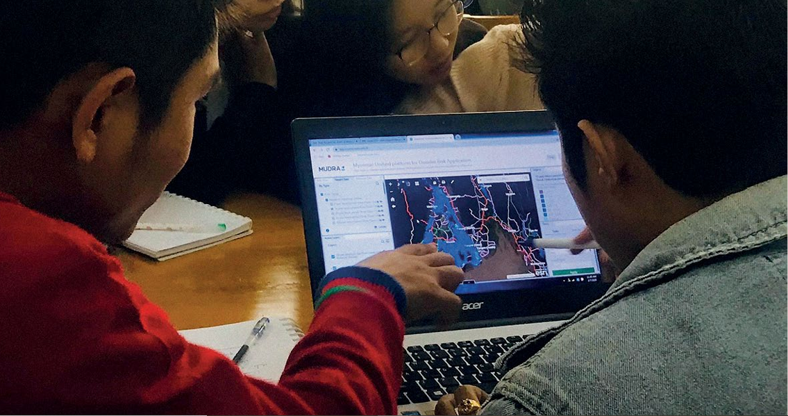
Development of MUDRA and its Applications
Under the MAPDRR (2017), one of the 32 priority areas focuses on understanding disaster risks by undertaking a national comprehensive multi-hazard and probabilistic risk assessment. In line with the national priority, the project on “Strengthening Climate and Disaster Resilience of Myanmar Communities” was implemented to contribute to a disaster risk modelling for three major hazards; cyclones wind, storm surge, and riverine floods at the national level. In this connection, developing the Myanmar Unified platform for Disaster Risk Application (MUDRA) was led by the Department of Disaster Management of the Ministry of Social Welfare, Relief and Resettlement in collaboration with other technical agencies and with technical support from the Asian Development Bank and financial assistance from the government of Canada.
MUDRA provides a decision support tool to government agencies and other disaster risk reduction practitioners to collaborate, share, and apply disaster risk information in the pursuit of risk informed development. Currently, MUDRA includes three priority hazards but intends to incorporate more hazard information in the future to be able to design a multi-hazard risk information platform. Modelling work was undertaken by Deltares (the Netherlands) in partnership with Royal Haskoning DHV, Wageningen University & Research, and OneMap to support the GIS platform. It is hosted in the OneMap Myanmar Portal with the intent of having an integrated platform across sectoral bodies and sharing the data among them. Modelling work started in February 2019 and it was undertaken through hands-on trainings, working sessions, technical meetings, and workshops. It contains hazard modelling, exposure modelling and vulnerability or damage functions (Technical Report, 2019).
Hazard Modelling
The Department of Meteorology and Hydrology of the Ministry of Transport and Communications has led the hazard modelling work along with other technical agencies. The probabilistic risk modelling approach has been adopted with a range of possible scenarios across the return periods (1 in 5, 10, 20, 50 and 100 years). Hazard modelling is also tasked for two climate change scenarios with Representative Concentration Pathways 4.5 and 8.5 for year 2040 and 2080 in accordance with the projections estimated by the Department of Meteorology and Hydrology and Environmental Conservation Department. It allows the users to understand the possible risk scenarios and potential impacts triggered by the changing climate.
Exposure Modelling
It is one of the most important aspects of risk modelling with more than 18 line departments sharing their data for exposure modelling. The current exposure data set covers population (disaggregated by age, sex, disability), types of housing, crops, livestock, school locations, warehouses, embankments, dams, cyclone shelters, high-ways, village connection roads and etc. Overall, 60 layers of data under seven components are made available in the exposure modelling. Moreover, the Department of Disaster Management has coordinated a field survey of 400 existing multi-purpose shelters in Ayeyarwady Region which enables the platform to provide detailed attributes of the cyclone shelter locations and their conditions.
Vulnerability Modelling
Vulnerability modelling or damage functions indicate the damage ratio for various intensities of the hazard (damage vs. wind speed or damage vs. water depth). One of the main challenges in the advanced model is that there is no recorded data for damages on housing, agriculture, and other sectors from small and medium scale disasters. Thus, in consultation with sector departments, the additional surveys to collect detailed damage data for housing, agriculture, livestock, and aquaculture from recent floodings in Ayeyarwady, Mon, Magway and Sagaing Regions were carried out.
Contribution of MUDRA
MUDRA was built with six main indicators and nine sub indicators derived from the Sendai Framework for Disaster Risk Reduction seeking to quantify disaster risk. Risk can be explored at the township level which is the fundamental administrative unit for different return periods and for climate change scenarios. The development of MUDRA has strengthened the capability of government officials to analyse risk and apply Geo-informatics in their primary work. The use of MUDRA has contributed to better planning, with the government prioritising limited resources based on needs and emerging risks. It offers user-friendly maps and curves for improved visualisation in disaster management and development plans. Depending on the risk landscape, effective risk reduction measures in sectoral and localised development endeavors can be undertaken.
Location specific risk data and information are critical to understanding climate and disaster risk and further taking the necessary actions on preparedness, prevention, response, and mitigation. More importantly, risk modelling work helps disaster managers become aware of the potential impacts of disasters in light of future climate projections. Based on the findings of the risk modelling platform, exposed populations, critical infrastructure, livelihoods, vulnerable groups, GDP can be projected, making the platform an indispensable tool for risk-informed decision-making. The results of the disaster risk modelling are available at the online interactive portal (https://www.mudra-ddm.info) (Policy Notes, 2019). To sum up, MUDRA will be able to support the exchange of disaster risk information among agencies in Myanmar, to promote a culture of risk-informed development and contribute to the implementation of the MAPDRR and the Sendai Framework for Disaster Risk Reduction.