

The Haiyan disaster
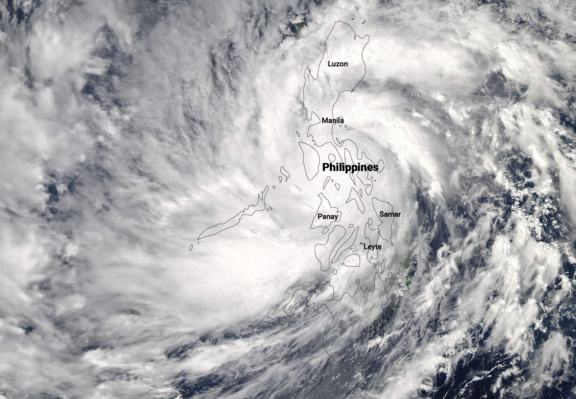
Ten years ago, on 8 November 2013, Supertyphoon Haiyan (local name Yolanda) barreled through the central region of the Philippines. The cyclone was one of the most powerful to make landfall in recorded history, killing thousands and leaving communities in ruins. Storm surges were primarily responsible for the 6,300 dead, 1,062 missing, and 28,688 injured in Haiyan's wake.
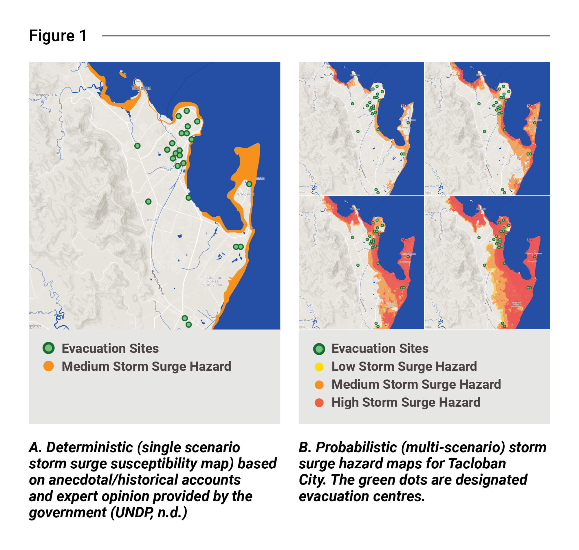
As in all disasters, a cycle of blame followed in its wake. Many were quick to assign culpability as the anger and pain from calamity loss demanded explanations. Among the many perspectives on what caused the disaster, one stands out: the national government hazard maps which were necessary for planning an appropriate response, underestimated the extent of the storm surges (Figure 1A). This miscalculation severely hampered all preparatory measures. Pre-positioned goods were washed away, and search and rescue personnel became victims themselves.
An examination of the location of evacuation centres in Tacloban revealed that nearly all were placed outside government-designated storm surge danger zones. Tragically, many who followed the forced evacuation protocol perished. They were assured safe refuge from the predicted 5- to 6-metre high storm surges, but seawater reached as far as 2 kilometres inland, flooding designated evacuation centres.
Why probabilistic risk assessment is a smarter approach
The storm surge hazard maps prepared by the government before Haiyan represented the worst-case scenario based on historical accounts (Figure 1A). This approach, known as “deterministic risk assessment,” relied on anecdotal accounts and expert opinion, without considering the possibility of events larger than those in recorded history. As a result, the maps failed to anticipate future events that were even more catastrophic than previously documented.
What was needed before Haiyan struck were hazard maps that simulated hazards larger than those remembered. Future disaster simulations, especially taking climate change into account, are essential for more accurate hazard profiling. A probabilistic approach, which models multiple scenarios—including both historical and unprecedented events—would have been a lifesaving tool.
In the case of Haiyan, “probabilistic risk assessments” using multi-scenario hazard maps were not yet available at that time. Such tools could have saved thousands of lives. Figure 1B, for example, shows a probabilistic storm surge map for Tacloban City, where the largest scenario with a 90-year return period is shown. This map, which is comparable to the inundation of the storm surges of Haiyan, indicates that almost all the evacuation centres were in storm surge-exposed areas. This type of information is critical in anticipating future disasters and planning effective response actions.
Mapping of Haiyan-affected and other hazard-prone areas
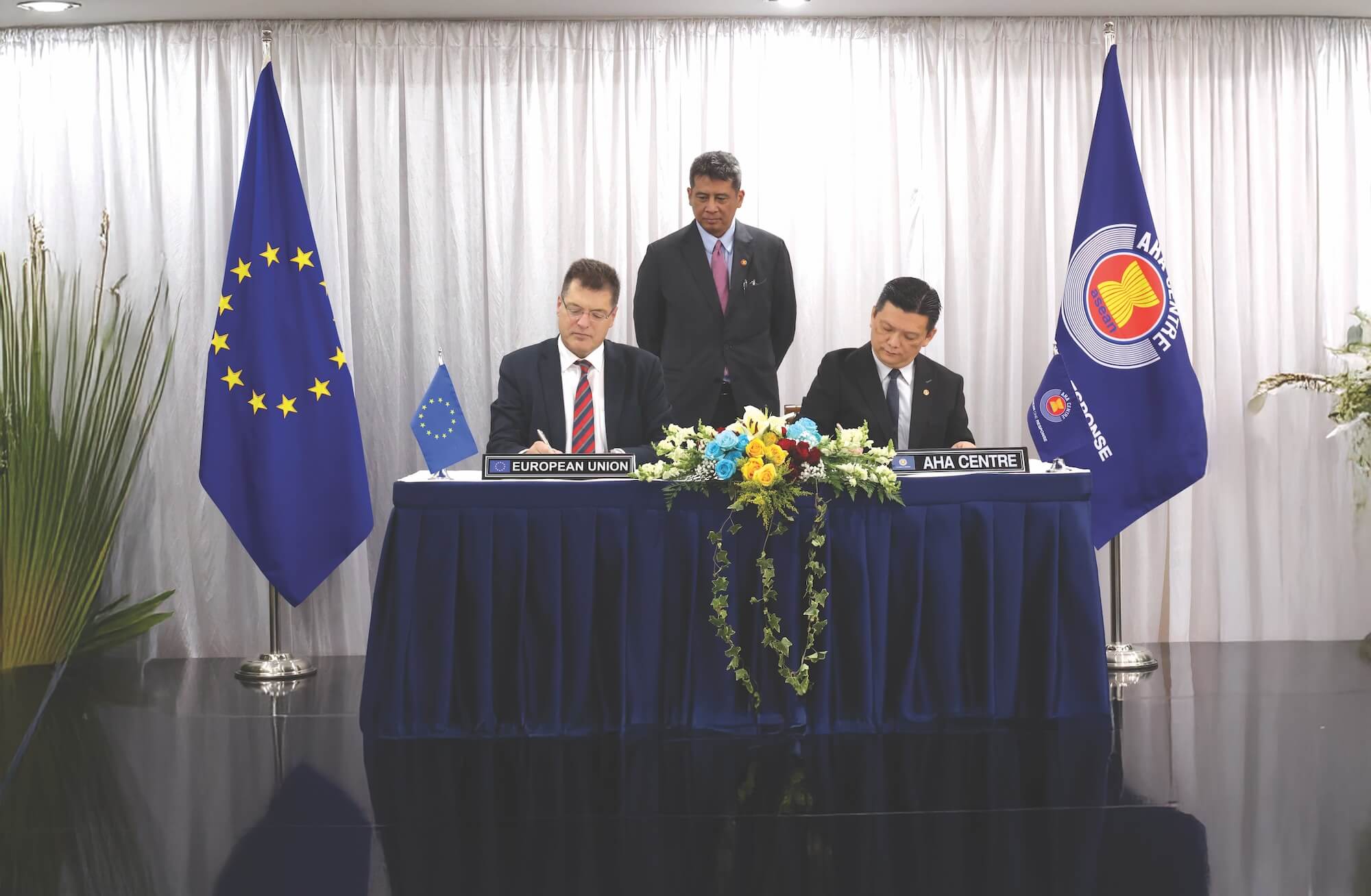
A year after the Haiyan disaster, in 2014, probabilistic flood hazard maps, along with landslide and storm surge maps, were produced for 171 cities and municipalities affected by the super typhoon. These maps were created through the Nationwide Operational Assessment of Hazards (NOAH) Project of the Department of Science and Technology (DOST) or DOST-Project NOAH, which at the time was the flagship programme for disaster risk reduction in the Philippines. This initiative was formally backed by the Joint Memorandum Circular No. 2014-01, titled “Adoption of Hazard Zone Classification in Areas Affected by Typhoon Haiyan and Providing Guidelines for Activities Therein,” issued by five agencies, the Philippines’ Department of Environment and Natural Resources, Department of the Interior and Local Government, Department of National Defense, Department of Public Works and Highways, and DOST. This memorandum provided the necessary framework for the use of high-resolution probabilistic maps.
The maps, which may be accessed by the general public through the http://noah.up.edu.ph website, were distributed to local government units (LGUs) across the Haiyan Corridor. However, the systematic integration of these multi-scenario hazard maps into comprehensive development plans, disaster risk reduction management plans, and local climate change action plans was inconsistent across local government units nationwide.
The probabilistic storm surge maps created for Tacloban City and other areas affected by Haiyan depicted scenarios with varying levels of inland inundation (Figure 1B). The Deutsche Gesellschaft für Internationale Zusammenarbeit (GIZ) regarded the largest scenario as the most reliable. According to a GIZ report, this scenario demonstrated that many of the designated evacuation centres were exposed to storm surges.
A people-centred early warning system
An effective “end-to-end” and “people-centred” early warning system involves an integrated system of hazard monitoring, forecasting and prediction, disaster risk assessment, communication, and preparedness activities systems and processes. It allows individuals, communities, governments, businesses, and others to prepare and take timely action against imminent hazards.
The people-centred early warning system includes four interrelated key elements: i) disaster risk knowledge based on the systematic collection of data and disaster risk assessments; ii) detection, monitoring, analysis, and forecasting of the hazards and possible consequences; iii) dissemination and communication, by an official source, of authoritative, timely, accurate and actionable warnings and associated information on likelihood and impact; and iv) preparedness at all levels to respond to the warnings received (Figure 2).
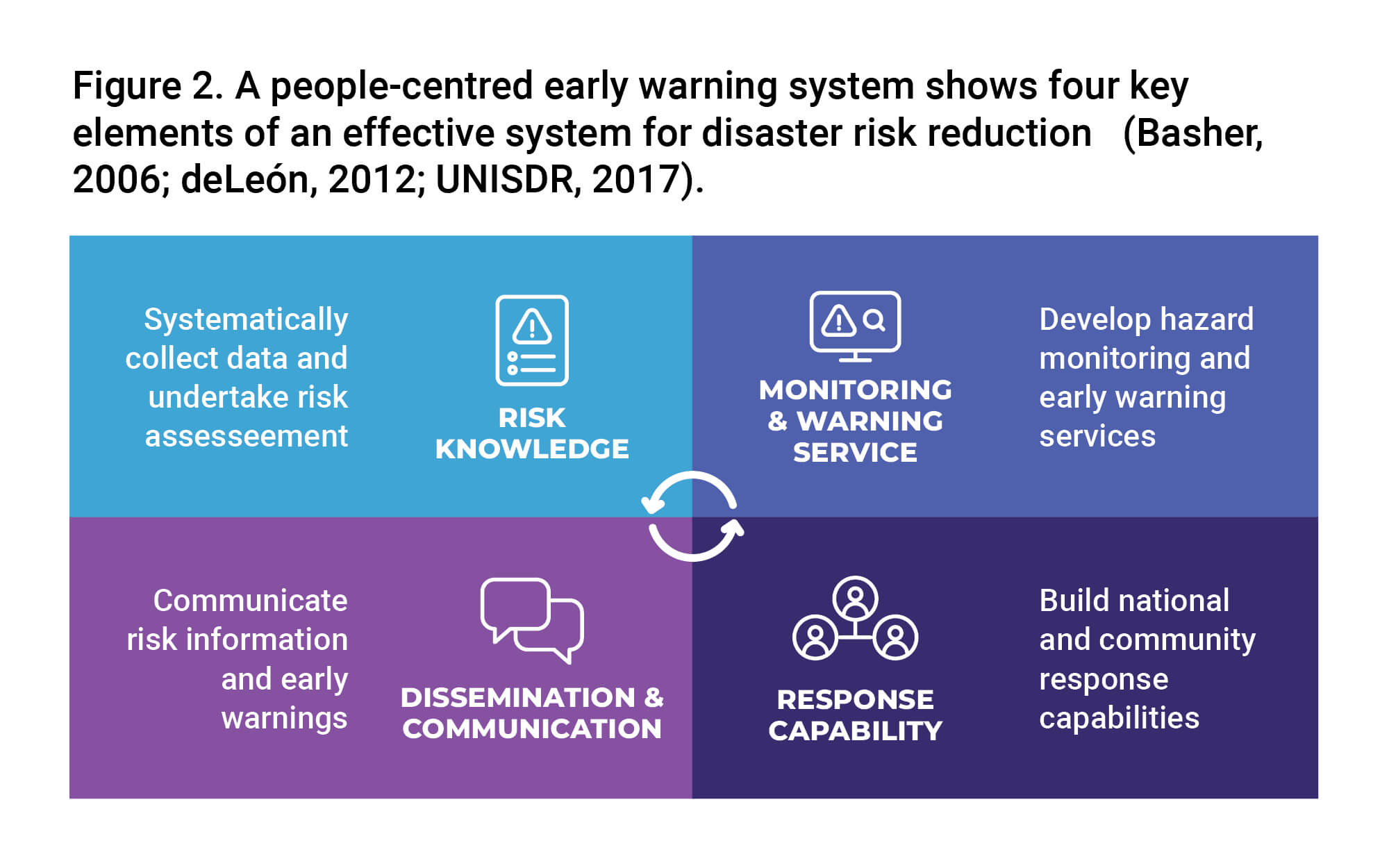
The interrelated components of a people-centred early warning system need to be coordinated within and across sectors and multiple levels for the system to work effectively and to include a feedback mechanism for continuous improvement. Failure in one component or a lack of coordination across them could lead to the failure of the whole system.
Institutionalising pre-disaster risk assessment
The Philippines’ disaster efforts have incorporated all four key components of an effective people-centred early warning system. Learning from Haiyan and responding to the need to strengthen disaster risk reduction efforts, the National Disaster Risk Reduction Management Council (NDRRMC) institutionalised the Pre-disaster Risk Assessment (PDRA) on 11 June 2014. PDRA evaluates the risk level of hazards based on exposure and vulnerability in specific areas incorporating both historical and probabilistic scenarios to address all potential risks. It presents the possible impacts and forms a basis for appropriate responses from both national and local government agencies.
PDRA provides risk analysis and constant monitoring of hydrometeorological hazards, supported by scientific information. It generates hazard-specific, time-bound, and area-focused assessments of probable impacts. These calibrated assessments trigger the implementation of action plans and protocols by organisations and units at all levels.
PDRA involves multi-agency discussions to identify areas likely to be affected based on weather forecasts. Because weather forecasts are never perfect, real-time measurements and weather satellite data are used to complement forecast information. This process requires round-the-clock monitoring while a cyclone is within the Philippine Area of Responsibility.
The output of this monitoring is then used by the NDRRMC to provide “hazard-specific, area-focused, and time-bound” warnings. For instance, when more than 100 mm of rainfall is observed in a particular area, the NDRRMC notifies the local mayor or DRRM officer to explain the situation scientifically. Feedback from local officials ensures that appropriate action is taken.
Since PDRA was established, it has helped avert approximately 15 disasters based on counterfactual evidence. Unfortunately, in 2017, DOST-Project NOAH ceased to be part of the NDRRMC. As a result, the detailed warnings that DOST-Project NOAH used to provide during PDRA were lost. Additionally, the promotion of probabilistic risk assessment as outlined in the 2014 Joint Memorandum Circular was not further developed.
Learning from the tragedy of Haiyan
On a national scale, the government reverted to single-scenario deterministic risk assessments to craft comprehensive land use and development plans for communities. These single-scenario deterministic hazard maps, available on the government’s GeoriskPH website, are still the maps officially recommended for use by local government units. This is despite provisions contained in the National Climate Risk Management Framework and the Philippine Development Plans of 2017-2022 and 2023-2028, which require the probabilistic risk assessment approach.
It is tragic that the most crucial lesson from the Haiyan disaster has not been learned. If we could only hear the voices of the victims, they would implore us not to repeat the same costly mistake—a miscalculation they paid for with their lives.
Dr. Alfredo Mahar Francisco A. Lagmay is a renowned geologist and disaster science expert who headed DOST’s Project NOAH. After the project concluded in 2017, it was adopted by the University of the Philippines’ Resilience Institute and serves as its core component, tasked with conducting research and public service related to climate and disaster resilience efforts. Dr. Lagmay is now at the helm of both the Institute and the UP NOAH.
This article contains excerpts from Lagmay and Racoma (2018) and Lagmay et al. (2024). References therein were used in writing this article.
The views and opinions expressed in this article are solely those of the author and do not reflect the official policy or position of ASEAN.